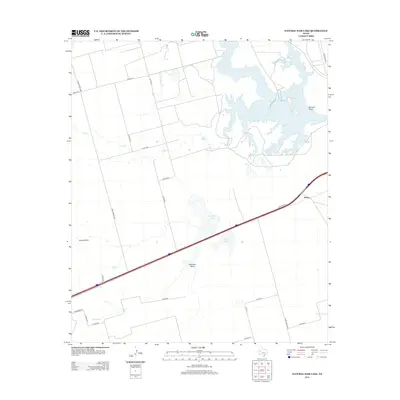
2012 Map of Natural Dam Lake
USGS Topo · Published 2012About this map
Natural Dam Lake dominates this arid landscape in Howard County, where the desert hydrology is defined by seasonal draws and isolated water tanks. The tiny settlement of Morita sits at a highway junction in the east, serving as a localized hub in an area otherwise characterized by extensive ranching and county roads like Ranch Road 3033. The geography here is marked by low-lying depressions that collect mineral-heavy runoff, as seen in the names Red Salt Lake and Salt Lake. These features, along with Hamilton Draw and Buzzard Draw, suggest a terrain shaped by rare but significant drainage events. Local landmarks like Indian Point and various livestock tanks, such as Calf Tank and Red Tank, provide essential orientation points across the open range. The network of corridors, including Compress Rd and Wilkerson Rd, illustrates the grid-like development of this part of West Texas.
Find a feature on this map
29 named features on this map. Tap any name to fly to it.
Don’t see what you’re looking for? This feature index may not catch every label — zoom into the map to look around manually.
Map Details
Editions of this 2012 Natural Dam Lake Map
This is the sole edition of this map. No revisions or reprints were ever made.
Other maps of this area

1941 · Morita
USGS Topo · 1:62,500

1949 · Morita
USGS Topo · 1:62,500

1954 · Big Spring
USGS Topo · 1:250,000

1958 · Big Spring
USGS Topo · 1:250,000
1966 · Lucian Wells Ranch
USGS Topo · 1:24,000

1966 · Natural Dam Lake
USGS Topo · 1:24,000

1966 · Knott SE
USGS Topo · 1:24,000
1966 · Elbow
USGS Topo · 1:24,000
1966 · Houston Ranch
USGS Topo · 1:24,000

1966 · Stanton
USGS Topo · 1:24,000