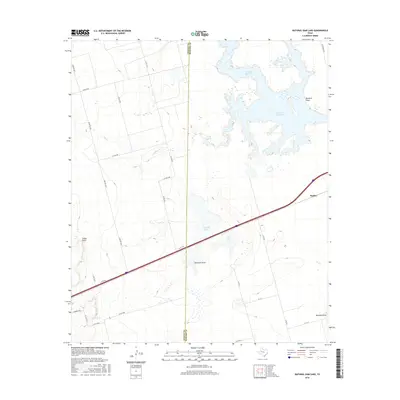
2016 Map of Natural Dam Lake
USGS Topo · Published 2016About this map
Natural Dam Lake and its intricate shoreline dominate the upper eastern corner of this West Texas landscape, which is bisected by the border between Martin and Howard Counties. The terrain is defined by a series of ephemeral water features and drainage channels, including Buzzard Draw, Hamilton Draw, and Mustang Draw, along with localized stock tanks such as Calf Tank and Red Tank. The small settlement of Morita sits near the eastern edge, adjacent to the path of the interstate.
Find a feature on this map
32 named features on this map. Tap any name to fly to it.
Don’t see what you’re looking for? This feature index may not catch every label — zoom into the map to look around manually.
Map Details
Editions of this 2016 Natural Dam Lake Map
This is the sole edition of this map. No revisions or reprints were ever made.
Other maps of this area

1941 · Morita
USGS Topo · 1:62,500

1949 · Morita
USGS Topo · 1:62,500

1954 · Big Spring
USGS Topo · 1:250,000

1958 · Big Spring
USGS Topo · 1:250,000
1966 · Lucian Wells Ranch
USGS Topo · 1:24,000

1966 · Natural Dam Lake
USGS Topo · 1:24,000

1966 · Knott SE
USGS Topo · 1:24,000
1966 · Elbow
USGS Topo · 1:24,000
1966 · Houston Ranch
USGS Topo · 1:24,000

1966 · Stanton
USGS Topo · 1:24,000