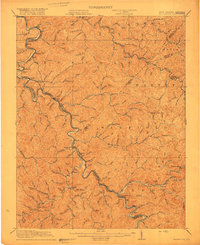
1917 Map of Naugatuck
USGS Topo · Published 1917About this map
Tug Fork carves a deep, winding path along the state boundary between West Virginia and Kentucky, serving as the central artery for transport and settlement in this rugged border region. The Norfolk and Western railroad snakes along the riverbank, connecting coal-rich industrial hubs and small railside communities such as Kermit, Naugatuck, and Warfield. Inland from the river, the landscape is a dense network of hollows and ridges, where isolated settlements like Breeden Breading PO and Wilsondale took root near the headwaters of Jennie Creek and Stonecoal Creek.
Find a feature on this map
135 named features on this map. Tap any name to fly to it.
Don’t see what you’re looking for? This feature index may not catch every label — zoom into the map to look around manually.
Map Details
Editions of this 1917 Naugatuck Map
3 editions found
Other maps of this area

1886 · Prestonsburg
USGS Topo · 1:125,000

1887 · Warfield
USGS Topo · 1:125,000

1891 · Warfield
USGS Topo · 1:125,000

1892 · Prestonsburg
USGS Topo · 1:125,000

1892 · Huntington
USGS Topo · 1:125,000

1898 · Huntington
USGS Topo · 1:125,000

1902 · Midkiff
USGS Topo · 1:62,500

1903 · Kenova
USGS Topo · 1:125,000

1904 · Kenova
USGS Topo · 1:125,000

1907 · Midkiff
USGS Topo · 1:62,500