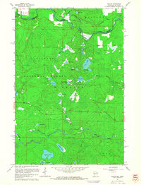
1962 Map of Naults
USGS Topo · Published 1964About this map
The Brule River and Pine River frame this heavily forested region of the Northwoods, marking the transition between Wisconsin and Michigan's Upper Peninsula. In the northern reaches, the Chicago and North Western railroad cuts across the Mastodon terrain, passing through the small settlement of Naults. Much of the landscape is protected within the Nicolet National Forest and Florence parklands, characterized by a dense concentration of glacial lakes. Features such as Whisker Lake, Edith Lake, and Savage Lake are interconnected by a network of drainage creeks including Armstrong Creek and Wakefield Creek. The presence of the Florence Lookout Tower suggests the importance of fire observation in this timber-rich era, while Pine Rapids along the southern river corridor highlights the natural hydrology of the watershed before significant modern development altered the remote character of the state line.
Find a feature on this map
35 named features on this map. Tap any name to fly to it.
Don’t see what you’re looking for? This feature index may not catch every label — zoom into the map to look around manually.
Map Details
Editions of this 1962 Naults Map
3 editions found
Other maps of this area

1898 · Iron River
USGS Topo · 1:62,500

1899 · Crystal Falls
USGS Topo · 1:62,500

1939 · Long Lake
USGS Topo · 1:48,000

1941 · Florence
USGS Topo · 1:48,000

1944 · Crystal Falls
USGS Topo · 1:24,000

1944 · Gaastra
USGS Topo · 1:24,000

1944 · Fortune Lakes
USGS Topo · 1:24,000

1946 · Crystal Falls
USGS Topo · 1:31,680

1946 · Gaastra
USGS Topo · 1:31,680

1946 · Fortune Lakes
USGS Topo · 1:31,680