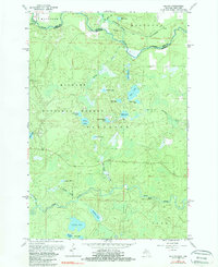
1962 Map of Naults
USGS Topo · Published 1981About this map
Naults stands as a quiet rail-stop outpost in the early 1960s, situated where the Chicago and North Western tracks cut through the heavily wooded terrain of the Nicolet National Forest. This survey captures the borderlands of the Upper Peninsula and Wisconsin before extensive modern development, defined by the winding course of the Brule River and the Pine River. The landscape is dominated by glacial lake systems and wetlands, including Whisker Lake, Savage Lake, and Pickerel Lake. Human activity is sparse but evident in infrastructure like the Florence Lookout Tower and isolated industrial sites such as Camp Thirteen Lake. The map details the complex drainage patterns of Armstrong Creek and Wakefield Creek, which flow through the town of Mastodon toward the primary river forks, illustrating a region still primarily dedicated to timber management and wilderness recreation during this era.
Find a feature on this map
37 named features on this map. Tap any name to fly to it.
Don’t see what you’re looking for? This feature index may not catch every label — zoom into the map to look around manually.
Map Details
Editions of this 1962 Naults Map
3 editions found
Other maps of this area

1898 · Iron River
USGS Topo · 1:62,500

1899 · Crystal Falls
USGS Topo · 1:62,500

1939 · Long Lake
USGS Topo · 1:48,000

1941 · Florence
USGS Topo · 1:48,000

1944 · Crystal Falls
USGS Topo · 1:24,000

1944 · Gaastra
USGS Topo · 1:24,000

1944 · Fortune Lakes
USGS Topo · 1:24,000

1946 · Crystal Falls
USGS Topo · 1:31,680

1946 · Gaastra
USGS Topo · 1:31,680

1946 · Fortune Lakes
USGS Topo · 1:31,680