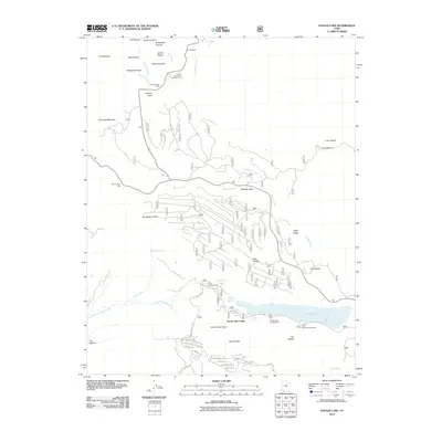
2011 Map of Navajo Lake
USGS Topo · Published 2011About this map
Navajo Lake serves as a central landmark in this 2011 survey of the high-elevation terrain where Iron and Kane Counties meet. The landscape is defined by its recreation-driven infrastructure, featuring multiple established sites like Te-ah Campground and the Navajo Lake Lodge. To the north, the map documents the complex rim topography near Point Supreme and The Bartizan, where drainage systems like Ashdown Creek and Arch Creek carve through the canyons. The presence of Cedar Breaks Lodge and several lookout points, including Zion Canyon View and Spectra Point, underscores the area's significance as a managed natural environment. Geologic features such as the Lava Desert and peaks like Andy Nelson Peak and Navajo Peak dominate the southern half, while a network of forest roads and loops connects the various springs and drainages throughout the plateau.
Find a feature on this map
52 named features on this map. Tap any name to fly to it.
Don’t see what you’re looking for? This feature index may not catch every label — zoom into the map to look around manually.
Map Details
Editions of this 2011 Navajo Lake Map
This is the sole edition of this map. No revisions or reprints were ever made.
Other maps of this area

1886 · Kanab
USGS Topo · 1:250,000

1953 · Cedar City
USGS Topo · 1:250,000

1954 · Orderville Canyon NW
USGS Topo · 1:24,000

1957 · Orderville Canyon NE
USGS Topo · 1:24,000

1958 · Cedar City
USGS Topo · 1:250,000

1958 · Orderville
USGS Topo · 1:62,500

1958 · Cedar Breaks
USGS Topo · 1:62,500

1958 · Panguitch Lake
USGS Topo · 1:62,500

1962 · Cedar City
USGS Topo · 1:250,000
1980 · Straight Canyon
USGS Topo · 1:24,000