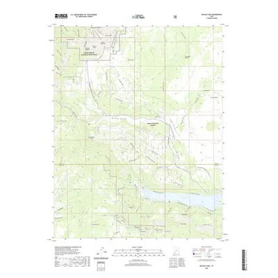
2020 Map of Navajo Lake
USGS Topo · Published 2020About this map
Cedar Breaks National Monument and the surrounding high plateau of the Dixie National Forest dominate this landscape on the boundary of Iron and Kane Counties. The high-altitude geography is defined by dramatic limestone formations like the Pink Cliffs and The Bartizan, while seasonal recreation is recorded through a network of snowmobile paths including the Bristlecone Snowmobile Trail and Deer Valley Loop C. At the heart of the region, Navajo Lake serves as a primary water feature, fed by numerous springs such as Larson Spring and Elderberry Spring. Evidence of early 20th-century industry persists at the Mitchell Sawmill site, located near the Markagunt Plateau. The map also details specialized hiking and livestock areas, such as the Virgin River Rim Trail and the Horse Pasture, illustrating the land's dual use for conservation and traditional western mountain utility.
Find a feature on this map
69 named features on this map. Tap any name to fly to it.
Don’t see what you’re looking for? This feature index may not catch every label — zoom into the map to look around manually.
Map Details
Editions of this 2020 Navajo Lake Map
This is the sole edition of this map. No revisions or reprints were ever made.
Other maps of this area

1886 · Kanab
USGS Topo · 1:250,000

1953 · Cedar City
USGS Topo · 1:250,000

1954 · Orderville Canyon NW
USGS Topo · 1:24,000

1957 · Orderville Canyon NE
USGS Topo · 1:24,000

1958 · Cedar City
USGS Topo · 1:250,000

1958 · Orderville
USGS Topo · 1:62,500

1958 · Cedar Breaks
USGS Topo · 1:62,500

1958 · Panguitch Lake
USGS Topo · 1:62,500

1962 · Cedar City
USGS Topo · 1:250,000
1980 · Straight Canyon
USGS Topo · 1:24,000