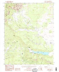
1985 Map of Navajo Lake
USGS Topo · Published 1985About this map
Navajo Lake sits as the central hydrologic feature of this high-elevation landscape, where the waters are hemmed in by the towering Pink Cliffs to the south. This 1980s field survey documents a wilderness defined by its dramatic geological breaks and volcanic remnants, including The Craters and a Cinder Pit near Horse Pasture. The map details the complex drainage systems of the Dixie National Forest, where headwaters like the North Fork Virgin River and Ashdown Creek begin their descent from the plateau. Significant recreational and administrative landmarks are noted, including Cedar Breaks National Monument at the northwestern edge and the Boy Scout Spring campground near the lake. The terrain is marked by sharp vertical relief, from the depths of Ashdown Gorge to the high observation points at Spectra Point and Point Supreme.
Find a feature on this map
62 named features on this map. Tap any name to fly to it.
Don’t see what you’re looking for? This feature index may not catch every label — zoom into the map to look around manually.
Map Details
Editions of this 1985 Navajo Lake Map
2 editions found
Other maps of this area

1886 · Kanab
USGS Topo · 1:250,000

1953 · Cedar City
USGS Topo · 1:250,000

1954 · Orderville Canyon NW
USGS Topo · 1:24,000

1957 · Orderville Canyon NE
USGS Topo · 1:24,000

1958 · Cedar City
USGS Topo · 1:250,000

1958 · Orderville
USGS Topo · 1:62,500

1958 · Cedar Breaks
USGS Topo · 1:62,500

1958 · Panguitch Lake
USGS Topo · 1:62,500

1962 · Cedar City
USGS Topo · 1:250,000
1980 · Straight Canyon
USGS Topo · 1:24,000