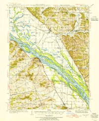
1934 Map of Nebo
USGS Topo · Published 1955About this map
The Mississippi River dominates this mid-1930s landscape, serving as a dynamic border between Illinois and Missouri. The river is a labyrinth of side channels and islands, including Pharrs Island, Carroll Island, and Slim Island, which separate the main navigation channel from the intricate network of the Sny River and its numerous backwater ponds like Halfmoon Lake. This complex hydrological environment dictated the placement of agricultural settlements and the paths of the Chicago and Alton RR and the Burlington and Quincy RR. Inland, the terrain rises sharply from the floodplain into the knobs and hollows of Martinsburg and Pleasant Hill, where small rural schools such as Oakland Sch and Fruit Ridge Sch served dispersed farming families. The presence of Riprap Landing and the Green Wing Club suggests the river's dual role in both commerce and early 20th-century recreation.
Find a feature on this map
128 named features on this map. Tap any name to fly to it.
Don’t see what you’re looking for? This feature index may not catch every label — zoom into the map to look around manually.
Map Details
Editions of this 1934 Nebo Map
4 editions found
Other maps of this area

1890 · Louisiana
USGS Topo · 1:125,000

1924 · Griggsville
USGS Topo · 1:62,500

1926 · Griggsville
USGS Topo · 1:62,500

1926 · Pittsfield
USGS Topo · 1:62,500

1930 · Pearl
USGS Topo · 1:62,500

1930 · Nebo
USGS Topo · 1:62,500

1930 · Hardin
USGS Topo · 1:62,500

1931 · Barry
USGS Topo · 1:62,500

1934 · Nebo
USGS Topo · 1:48,000

1934 · Elsberry
USGS Topo · 1:48,000