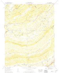
1959 Map of Nebo
USGS Topo · Published 1960About this map
Nebo sits within the Rich Valley at the foot of Walker Mountain, serving as a central point for the farming and timber landscape of the late 1950s. The Tennessee Valley Authority documented this complex terrain where the North Fork Holston River winds through narrow gaps between massive ridges like Brushy Mountain and Carter Mountain. This area is particularly dense with family history markers, featuring numerous small burial grounds such as Ezelle Ch Goodman Cem, Hubble Cem, and Davis Cem.
Find a feature on this map
75 named features on this map. Tap any name to fly to it.
Don’t see what you’re looking for? This feature index may not catch every label — zoom into the map to look around manually.
Map Details
Editions of this 1959 Nebo Map
4 editions found
Other maps of this area

1887 · Pocahontas
USGS Topo · 1:125,000

1889 · Wytheville
USGS Topo · 1:125,000

1891 · Tazewell
USGS Topo · 1:125,000

1891 · Pocahontas
USGS Topo · 1:125,000

1891 · Abingdon
USGS Topo · 1:125,000

1892 · Wytheville
USGS Topo · 1:125,000

1894 · Pocahontas
USGS Topo · 1:125,000

1894 · Abingdon
USGS Topo · 1:125,000

1895 · Tazewell
USGS Topo · 1:125,000

1895 · Pocahontas
USGS Topo · 1:125,000