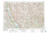
1955 Map of Nebraska City
USGS Topo · Published 1976About this map
The Missouri River forms the twisting spine of this mid-century regional survey, separating the bluffs of Nebraska City and Plattsmouth from the expansive floodplains of southwest Iowa and northwest Missouri. The landscape is defined by its major watercourses, including the Nishnabotna River and the uniquely named One Hundred and Two River, which drain the fertile agricultural uplands. Significant conservation areas are already established, notably the Squaw Creek National Wildlife Refuge and a network of recreation sites like Waubonsie State Park and Viking Lake State Park. Along the southern border, the Sac and Fox-Iowa Indian Res sits near Falls City, illustrating the intersection of tribal lands and colonial-era settlement patterns. The infrastructure of the Burlington Northern railroad links established centers such as Shenandoah, Maryville, and Clarinda, tracing the development of the Tri-State region.
Find a feature on this map
98 named features on this map. Tap any name to fly to it.
Don’t see what you’re looking for? This feature index may not catch every label — zoom into the map to look around manually.
Map Details
Editions of this 1955 Nebraska City Map
3 editions found

Other maps of this area

1885 · Atchison
USGS Topo · 1:125,000

1888 · Atchison
USGS Topo · 1:125,000

1888 · Hiawatha
USGS Topo · 1:125,000

1889 · Seneca
USGS Topo · 1:125,000

1893 · Atchison
USGS Topo · 1:125,000

1893 · Fremont
USGS Topo · 1:125,000

1894 · Seneca
USGS Topo · 1:125,000

1894 · Hiawatha
USGS Topo · 1:125,000

1896 · Fremont
USGS Topo · 1:125,000

1903 · Weeping Water
USGS Topo · 1:125,000