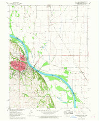
1966 Map of Nebraska City
USGS Topo · Published 1968About this map
Nebraska City sits prominently on the western bluffs of the Missouri River, serving as a busy regional hub where the Chicago Burlington and Quincy and Missouri Pacific railroads intersect. The city's landscape is defined by its deep historical roots, visible through the grounds of Arbor Lodge State Park and a network of neighborhood schools like the 2d Ave Sch and 6th St Sch. Across the wide river bottomlands in Iowa, the map reveals a starkly different, low-lying environment managed by the West Benton Ditch and Possum Creek.
Find a feature on this map
49 named features on this map. Tap any name to fly to it.
Don’t see what you’re looking for? This feature index may not catch every label — zoom into the map to look around manually.
Map Details
Editions of this 1966 Nebraska City Map
2 editions found
Other maps of this area

1907 · Nebraska City
USGS Topo · 1:62,500

1935 · Nehawka
USGS Topo · 1:48,000

1939 · Hamburg
USGS Topo · 1:62,500

1940 · Nehawka
USGS Topo · 1:62,500

1941 · Hamburg
USGS Topo · 1:62,500

1955 · Nebraska City
USGS Topo · 1:250,000

1957 · Nebraska City
USGS Topo · 1:250,000

1957 · Tabor SW
USGS Topo · 1:24,000

1958 · Nebraska City
USGS Topo · 1:250,000
1966 · Nebraska City NW
USGS Topo · 1:24,000