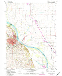
1966 Map of Nebraska City
USGS Topo · Published 1984About this map
The Missouri River dominates this mid-1960s landscape, serving as the border between Nebraska City, Nebraska, and the floodplain of Fremont County, Iowa. The city itself is a dense hub of institutional and civic life, anchored by the Arbor Lodge State Park and a network of parochial and public education centers like St Marys High Sch and the 14th St Sch. To the south, the terrain becomes more broken, carved by Threemile Creek and Fourmile Creek as they drain toward the river. Local infrastructure is well-defined, featuring the Waterworks and St Mary Hospital, while the Burlington Northern railroad lines underscore the area's role as a transportation corridor. In the surrounding rural stretches, multiple cemeteries such as Wyuka Cemetery and Blanchard Cem offer valuable points of reference for genealogical research.
Find a feature on this map
42 named features on this map. Tap any name to fly to it.
Don’t see what you’re looking for? This feature index may not catch every label — zoom into the map to look around manually.
Map Details
Editions of this 1966 Nebraska City Map
2 editions found
Other maps of this area

1907 · Nebraska City
USGS Topo · 1:62,500

1935 · Nehawka
USGS Topo · 1:48,000

1939 · Hamburg
USGS Topo · 1:62,500

1940 · Nehawka
USGS Topo · 1:62,500

1941 · Hamburg
USGS Topo · 1:62,500

1955 · Nebraska City
USGS Topo · 1:250,000

1957 · Nebraska City
USGS Topo · 1:250,000

1957 · Tabor SW
USGS Topo · 1:24,000

1958 · Nebraska City
USGS Topo · 1:250,000
1966 · Nebraska City NW
USGS Topo · 1:24,000