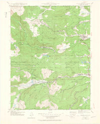
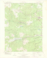
1942 Map of Nederland
USGS Topo · Published 1964About this map
High-country mining and rail operations define this 1942 survey of the Front Range, where the Denver and Salt Lake railroad winds through the canyon toward Tolland and Rollinsville. The landscape is a complex network of industrial history, featuring numerous extraction sites like the Bluebird Mine, Conger Mine, and Primos Mine alongside timber operations such as the Zarlengo Saw Mill. The town of Nederland sits at the eastern edge near the Barker Reservoir, serving as a hub for the scattered settlements of Eldora, Cardinal, and the high-elevation Caribou. The intersection of Boulder Co and Gilpin Co lines near Buckeye Mtn highlights the region's historical administrative boundaries. This map captures the area before modern recreation dominated the landscape, showing the original footprints of ranching sites like the Sayre Ranch and the Lazy W Ranch amidst the expansive Roosevelt National Forest.
Find a feature on this map
83 named features on this map. Tap any name to fly to it.
Don’t see what you’re looking for? This feature index may not catch every label — zoom into the map to look around manually.
Map Details
Editions of this 1942 Nederland Map
6 editions found
Other maps of this area

1899 · West Denver
USGS Topo · 1:125,000

1902 · Boulder
USGS Topo · 1:62,500

1904 · Boulder
USGS Topo · 1:62,500

1905 · Central City
USGS Topo · 1:62,500

1906 · Blackhawk
USGS Topo · 1:62,500

1910 · Central City
USGS Topo · 1:62,500

1912 · Central City
USGS Topo · 1:62,500

1915 · Longs Peak
USGS Topo · 1:125,000

1919 · Rocky Mountain National Park
USGS Topo · 1:125,000

1942 · Nederland
USGS Topo · 1:24,000
Featured Places
- Nederland, CO
- Caribou City, CO
- Rollinsville, CO
- East Portal Distributed Camping Area, CO
- West Magnolia Campground, CO