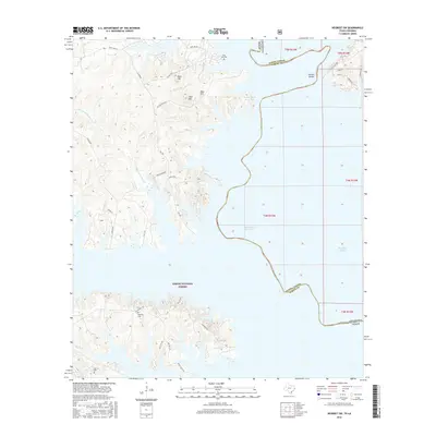
2016 Map of Negreet SW
USGS Topo · Published 2016About this map
Toledo Bend Reservoir dominates the eastern half of this landscape, its irregular shoreline forming a complex boundary between Louisiana and Texas. The flooded valley has submerged older features, yet high ground such as Rock Hill, Sand Hill, and Moss Hill remain prominent landmarks above the western banks. Within the protected reaches of the Sabine National Forest, the map preserves the locations of local family heritage sites, including Oak Hill Cem, McCord Cem, and Isaac Low Cem. Drainage patterns are defined by a network of creeks and bayous including Hurricane Bayou and Miles Cr that feed into the reservoir. A transition from traditional roads like El Camino to modern forest routes like Lakeview Rd and Gilley Pt Rd reflects the era's focus on timber management and recreational access along the Sabine Parish shoreline.
Find a feature on this map
43 named features on this map. Tap any name to fly to it.
Don’t see what you’re looking for? This feature index may not catch every label — zoom into the map to look around manually.
Map Details
Editions of this 2016 Negreet SW Map
This is the sole edition of this map. No revisions or reprints were ever made.
Other maps of this area

1944 · Negreet
USGS Topo · 1:62,500

1944 · Wiergate
USGS Topo · 1:62,500

1948 · Wiergate
USGS Topo · 1:62,500

1953 · Alexandria
USGS Topo · 1:250,000

1954 · Toro
USGS Topo · 1:24,000

1954 · Columbus
USGS Topo · 1:24,000

1954 · Fairdale
USGS Topo · 1:24,000
1954 · Negreet
USGS Topo · 1:24,000

1954 · Negreet
USGS Topo · 1:62,500

1954 · Wiergate
USGS Topo · 1:62,500