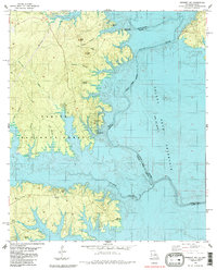
1985 Map of Negreet SW
USGS Topo · Published 1985About this map
The Toledo Bend Reservoir dominates this mid-1980s landscape, illustrating the submerged borderlands between Texas and Louisiana. The intricate shoreline is carved by numerous inlets where former land features like Housen Bayou and Lowes Creek meet the reservoir's waters. On the western side, the Sabine National Forest preserves the wooded terrain, dotted with family-named landmarks such as Sand Hill and Rock Hill. Local history is anchored by the Oak Hill Ch and several burial grounds, including the Isaac Low Cem near the northern boundary and Mc Cord Cem in the south. The mapping of the Indian Mounds Recreation Area and Harpers Ridge Recreation Area reflects the era's focus on public land management and outdoor access along the Sabine River valley.
Find a feature on this map
26 named features on this map. Tap any name to fly to it.
Don’t see what you’re looking for? This feature index may not catch every label — zoom into the map to look around manually.
Map Details
Editions of this 1985 Negreet SW Map
This is the sole edition of this map. No revisions or reprints were ever made.
Other maps of this area

1944 · Negreet
USGS Topo · 1:62,500

1944 · Wiergate
USGS Topo · 1:62,500

1948 · Wiergate
USGS Topo · 1:62,500

1953 · Alexandria
USGS Topo · 1:250,000

1954 · Toro
USGS Topo · 1:24,000

1954 · Columbus
USGS Topo · 1:24,000

1954 · Fairdale
USGS Topo · 1:24,000
1954 · Negreet
USGS Topo · 1:24,000

1954 · Negreet
USGS Topo · 1:62,500

1954 · Wiergate
USGS Topo · 1:62,500