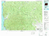
1979 Map of Nehalem River
USGS Topo · Published 1989About this map
The Nehalem River winds through a heavily forested landscape defined by the expansive Tillamook State Forest and Clatsop State Forest. This late-twentieth-century survey documents the transition from the timber-rich interior mountains, including peaks like Saddle Mountain and Kings Mountain, to the busy coastal communities along the Pacific Ocean. Settlement patterns are concentrated at the water's edge, from the resort towns of Cannon Beach and Rockaway to the industrial and fishing hubs at Garibaldi and Bay City on Tillamook Bay. Transportation infrastructure is a central feature, showing the Burlington Northern Railroad and Southern Pacific Railroad navigating the river valleys alongside the Sunset Highway. The map also highlights the complex drainage systems of the Salmonberry River and Gales Creek, which carved the routes for early rail and road development.
Find a feature on this map
108 named features on this map. Tap any name to fly to it.
Don’t see what you’re looking for? This feature index may not catch every label — zoom into the map to look around manually.
Map Details
Editions of this 1979 Nehalem River Map
3 editions found
Other maps of this area

1915 · Hillsboro
USGS Topo · 1:62,500

1916 · Tualatin
USGS Topo · 1:62,500

1918 · Hillsboro
USGS Topo · 1:62,500

1919 · Mayger
USGS Topo · 1:62,500

1919 · Astoria
USGS Topo · 1:62,500

1921 · Kalama
USGS Topo · 1:62,500

1922 · St. Helens
USGS Topo · 1:62,500

1937 · Nehalem
USGS Topo · 1:62,500

1937 · Enright
USGS Topo · 1:62,500

1939 · Astoria
USGS Topo · 1:62,500