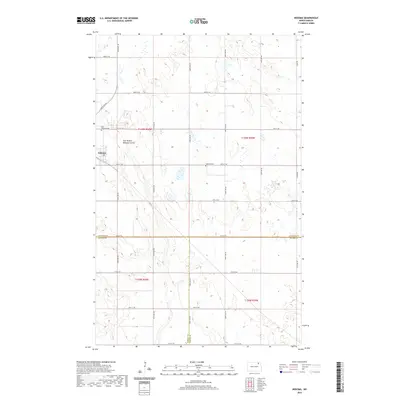
2020 Map of Nekoma
USGS Topo · Published 2020About this map
The small settlement of Nekoma serves as the focal point of this rural prairie landscape, positioned near the intersection of 81st St NE and 106th Ave NE. The terrain is defined by the subtle drainage of the East Branch Nekoma Coulee and a dense network of sectional roads like Easby Rd and 80th St NE that parcel the agricultural land. This map captures a significant jurisdictional junction where the boundaries of Cavalier Co, Ramsey Co, and Walsh Co converge, highlighting the administrative geography of northeastern North Dakota. Genealogists will find interest in the local burial sites, specifically Saint Edwards Cem located to the northwest and Nekoma Cem situated just east of the primary township.
Find a feature on this map
27 named features on this map. Tap any name to fly to it.
Don’t see what you’re looking for? This feature index may not catch every label — zoom into the map to look around manually.
Map Details
Editions of this 2020 Nekoma Map
This is the sole edition of this map. No revisions or reprints were ever made.
Other maps of this area

1953 · Devils Lake
USGS Topo · 1:250,000

1956 · Devils Lake
USGS Topo · 1:250,000

1972 · Osnabrock
USGS Topo · 1:24,000

1972 · Nekoma
USGS Topo · 1:24,000

1972 · Easby
USGS Topo · 1:24,000

1972 · Osnabrock SW
USGS Topo · 1:24,000

1972 · Edmore
USGS Topo · 1:24,000

1972 · Fairdale
USGS Topo · 1:24,000

1972 · Edmore NE
USGS Topo · 1:24,000

1972 · Billings Lake
USGS Topo · 1:24,000