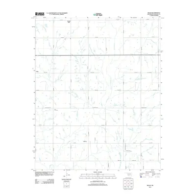
2012 Map of Nellie
USGS Topo · Published 2012About this map
Nellie, Oklahoma, and the surrounding Stephens County countryside appear here in the early twenty-first century, defined by a rigid grid of country roads and winding creek beds. The landscape is dominated by agricultural drainage patterns, with Little Beaver Cr and Rock Cr carving paths through the central and western sections of the township. Local history and genealogy interests are centered on small community hubs like Central High and Oil City, as well as the Rock Creek Cem located along W Camelback Rd. The map also documents modern water management features such as the Oknoname 137006 Reservoir and the uniquely named Hell Cr. This layout illustrates the persistence of section-line roads in Oklahoma's rural geography, where family-named routes like Gatlin Rd link isolated farmsteads and rural residences.
Find a feature on this map
38 named features on this map. Tap any name to fly to it.
Don’t see what you’re looking for? This feature index may not catch every label — zoom into the map to look around manually.
Map Details
Editions of this 2012 Nellie Map
This is the sole edition of this map. No revisions or reprints were ever made.
Other maps of this area

1901 · Addington
USGS Topo · 1:125,000

1902 · Rush Springs
USGS Topo · 1:125,000

1949 · Nellie
USGS Topo · 1:62,500

1950 · Marlow
USGS Topo · 1:62,500

1951 · Marlow
USGS Topo · 1:62,500

1955 · Lawton
USGS Topo · 1:250,000

1956 · Sterling
USGS Topo · 1:24,000
1956 · Denton
USGS Topo · 1:24,000

1956 · Letitia
USGS Topo · 1:24,000

1956 · Nellie
USGS Topo · 1:24,000