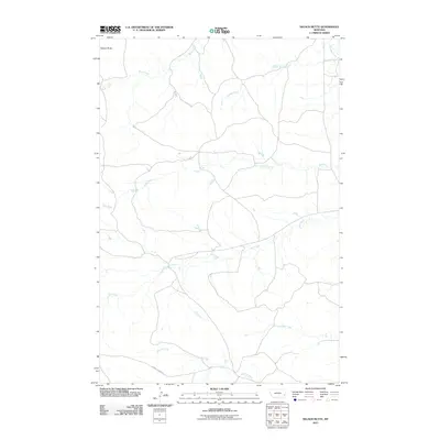
2011 Map of Nelson Butte
USGS Topo · Published 2011About this map
Nelson Butte rises in the northwest corner of this Fallon County landscape, overlooking a complex drainage system that defines the local geography. The area is characterized by a network of seasonal watercourses, including Back Creek, Stump Creek, and Ash Creek, which flow across the prairie toward the more prominent O'Fallon Creek in the northeast. This 2011 survey by the U.S. Geological Survey shows a sparse, wide-open territory primarily dedicated to ranching and local travel. A notable man-made feature is the Labree Cutacross, a road that bisects the southern reaches near Ranch Creek. The map provides a detailed view of the rural infrastructure of eastern Montana, where small bridges and low-water crossings connect the land across Mile Creek and Lone Tree Creek, illustrating the remote nature of the terrain in the early 21st century.
Find a feature on this map
9 named features on this map. Tap any name to fly to it.
Don’t see what you’re looking for? This feature index may not catch every label — zoom into the map to look around manually.
Map Details
Editions of this 2011 Nelson Butte Map
This is the sole edition of this map. No revisions or reprints were ever made.
Other maps of this area

1953 · Miles City
USGS Topo · 1:250,000

1957 · Miles City
USGS Topo · 1:250,000

1958 · Miles City
USGS Topo · 1:250,000

1981 · Baker
USGS Topo · 1:100,000
1981 · Skunk Creek
USGS Topo · 1:24,000

1981 · Harmon Butte
USGS Topo · 1:24,000

1981 · Nelson Butte
USGS Topo · 1:24,000

1981 · Bracket Butte SE
USGS Topo · 1:24,000
1981 · Hooky Dam
USGS Topo · 1:24,000
1981 · North Fork Alkali Creek
USGS Topo · 1:24,000