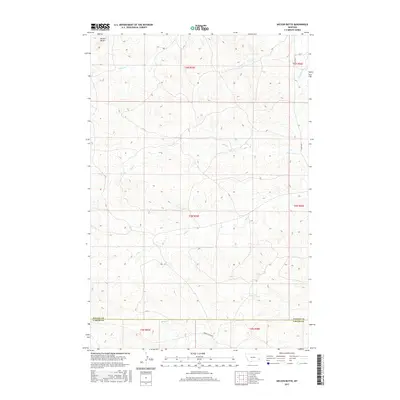
2017 Map of Nelson Butte
USGS Topo · Published 2017About this map
Nelson Butte dominates the northwestern corner of this landscape in southeastern Montana, serving as a prominent landmark in an area defined by its complex drainage network. The terrain is etched by numerous watercourses, including Stump Cr and O'Fallon Cr in the north, while Mile Cr and Ash Cr bisect the central portion of the quadrangle. This 2017 survey illustrates the sparse, high-plains infrastructure typical of the region, where the primary travel corridors are Ismay Rd S and the descriptive Labree Cutacross. The southern boundary of the map follows the political line between Fallon Co and Carter Co, crossing Ranch Cr near the edge of the survey area. Researchers will find a quiet, rural landscape where the topography is the most defining feature.
Find a feature on this map
17 named features on this map. Tap any name to fly to it.
Don’t see what you’re looking for? This feature index may not catch every label — zoom into the map to look around manually.
Map Details
Editions of this 2017 Nelson Butte Map
This is the sole edition of this map. No revisions or reprints were ever made.
Other maps of this area

1953 · Miles City
USGS Topo · 1:250,000

1957 · Miles City
USGS Topo · 1:250,000

1958 · Miles City
USGS Topo · 1:250,000

1981 · Baker
USGS Topo · 1:100,000
1981 · Skunk Creek
USGS Topo · 1:24,000

1981 · Harmon Butte
USGS Topo · 1:24,000

1981 · Nelson Butte
USGS Topo · 1:24,000

1981 · Bracket Butte SE
USGS Topo · 1:24,000
1981 · Hooky Dam
USGS Topo · 1:24,000
1981 · North Fork Alkali Creek
USGS Topo · 1:24,000