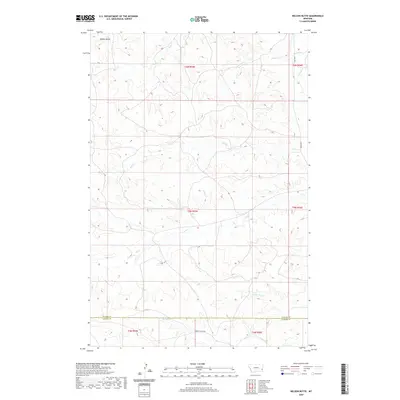
2020 Map of Nelson Butte
USGS Topo · Published 2020About this map
Nelson Butte rises as a prominent landmark in this eastern Montana landscape, marking the northern reaches of a territory defined by its intricate drainage systems. The terrain is deeply etched by numerous waterways including Stump Cr, Mile Cr, and Ash Cr, which flow toward the eastern boundary near O'Fallon Cr. These seasonal and perennial streams illustrate the erosional patterns typical of the region's sedimentary geography. The map documents the boundary line between Fallon County and Carter County in the south, where Ranch Cr and the Labree Cutacross provide critical east-west transit. The sparsely populated area is connected by a network of rural routes such as Ismay Rd S, serving the remote ranching properties and land sections within the township and range system.
Find a feature on this map
18 named features on this map. Tap any name to fly to it.
Don’t see what you’re looking for? This feature index may not catch every label — zoom into the map to look around manually.
Map Details
Editions of this 2020 Nelson Butte Map
This is the sole edition of this map. No revisions or reprints were ever made.
Other maps of this area

1953 · Miles City
USGS Topo · 1:250,000

1957 · Miles City
USGS Topo · 1:250,000

1958 · Miles City
USGS Topo · 1:250,000

1981 · Baker
USGS Topo · 1:100,000
1981 · Skunk Creek
USGS Topo · 1:24,000

1981 · Harmon Butte
USGS Topo · 1:24,000

1981 · Nelson Butte
USGS Topo · 1:24,000

1981 · Bracket Butte SE
USGS Topo · 1:24,000
1981 · Hooky Dam
USGS Topo · 1:24,000
1981 · North Fork Alkali Creek
USGS Topo · 1:24,000