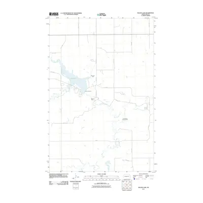
2011 Map of Nelson Lake
USGS Topo · Published 2011About this map
Nelson Lake and its industrial water management infrastructure dominate this North Dakota landscape in Oliver County. The reservoir is held by the Nelson Lake Dam, with the waters of Hagel Creek and Square Butte Creek feeding into the local drainage system. This 2011 survey illustrates a highly structured rural grid, where numbered sections are accessed by a network of local roads including 24th St SW and 33rd Ave SW.
Find a feature on this map
20 named features on this map. Tap any name to fly to it.
Don’t see what you’re looking for? This feature index may not catch every label — zoom into the map to look around manually.
Map Details
Editions of this 2011 Nelson Lake Map
This is the sole edition of this map. No revisions or reprints were ever made.
Other maps of this area

1954 · Bismarck
USGS Topo · 1:250,000

1954 · McClusky
USGS Topo · 1:250,000

1958 · Bismarck
USGS Topo · 1:250,000

1958 · McClusky
USGS Topo · 1:250,000

1968 · Hannover NE
USGS Topo · 1:24,000

1968 · Fort Clark
USGS Topo · 1:24,000
1968 · Fort Clark NE
USGS Topo · 1:24,000

1970 · New Salem NE
USGS Topo · 1:24,000

1972 · Center
USGS Topo · 1:24,000

1972 · Crown Butte NW
USGS Topo · 1:24,000