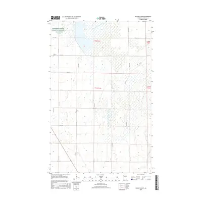
2016 Map of Nelson Slough
USGS Topo · Published 2016About this map
East Park Wildlife Management Area Reservoir dominates the northwestern landscape of Marshall County in this 2016 survey. The terrain is defined by a series of north-south and east-west roads, such as 150th Ave NW and 400th St NW, that create a rigid grid across the low-lying wetlands and agricultural fields. Genealogists and local historians can find two significant burial sites tucked into this grid: Wikstrom Cem in the west and Opdahl Cem centrally located near 140th Ave NW. Drainage and water management are central to the area's development, evidenced by the long reach of Judicial Ditch Number Nineteen and the winding course of the Middle River in the southeast. While much of the land remains under the Farm Service Agency Interest of Minnesota, the map also preserves the route of the Hunting Trl, reflecting the region's recreational and conservation priorities.
Find a feature on this map
27 named features on this map. Tap any name to fly to it.
Don’t see what you’re looking for? This feature index may not catch every label — zoom into the map to look around manually.
Map Details
Editions of this 2016 Nelson Slough Map
This is the sole edition of this map. No revisions or reprints were ever made.
Other maps of this area

1918 · Greenbush
USGS Topo · 1:62,500

1918 · Middle River
USGS Topo · 1:62,500

1919 · Pelan
USGS Topo · 1:62,500

1952 · Thief River Falls
USGS Topo · 1:250,000

1956 · Thief River Falls
USGS Topo · 1:250,000

1957 · Thief River Falls
USGS Topo · 1:250,000

1957 · Newfolden
USGS Topo · 1:62,500

1957 · Pelan
USGS Topo · 1:62,500

1962 · Strathcona
USGS Topo · 1:24,000
1962 · Middle River
USGS Topo · 1:24,000