1986 Map of Neosho
USGS Topo · Published 1990About this map
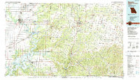
The Neosho River and Spring River converge in the southwest corner of this tri-state survey, feeding into the expansive Grand Lake O' The Cherokees. This 1980s landscape highlights the dense network of small mining and railroad towns along the Oklahoma and Kansas border, including Picher, Quapaw, and Commerce. The presence of numerous quarries and mines throughout the region reflects the enduring legacy of the Tri-State Mining District.
Find a feature on this map
138 named features on this map. Tap any name to fly to it.
Don’t see what you’re looking for? This feature index may not catch every label — zoom into the map to look around manually.
Map Details
Editions of this 1986 Neosho Map
2 editions found

Other maps of this area

1886 · Joplin
USGS Topo · 1:125,000

1886 · Greenfield
USGS Topo · 1:125,000

1886 · Carthage
USGS Topo · 1:125,000

1886 · Parsons
USGS Topo · 1:125,000

1888 · Greenfield
USGS Topo · 1:125,000

1893 · Parsons
USGS Topo · 1:125,000

1894 · Joplin
USGS Topo · 1:125,000

1894 · Carthage
USGS Topo · 1:125,000

1896 · Pryor
USGS Topo · 1:125,000

1899 · Fayetteville
USGS Topo · 1:125,000