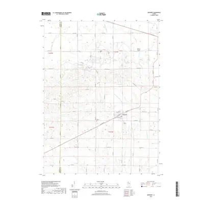
2018 Map of Neponset
USGS Topo · Published 2018About this map
The village of Neponset serves as the central hub of this agricultural landscape in Bureau County, where the grid of rural roads meets the headwaters of the E Fork Spoon River. The topography is defined by gentle drainage patterns like Tomahawk Cr and Lawson Cr, which weave between family-named sites and landmarks like Indian Hill. Local history is anchored by several burial grounds, including Floral Hill Cem and the namesake Neponset Cem, which provide essential touchpoints for genealogical research in the township. To the north, the Edwin G Bennett Airport represents the modernization of local transportation, while names like Mineral Cem and Barbara Ditch hint at the area's legacy of resource management and early settlement priorities across the Henry County border.
Find a feature on this map
47 named features on this map. Tap any name to fly to it.
Don’t see what you’re looking for? This feature index may not catch every label — zoom into the map to look around manually.
Map Details
Editions of this 2018 Neponset Map
This is the sole edition of this map. No revisions or reprints were ever made.
Other maps of this area

1921 · Buda
USGS Topo · 1:62,500

1923 · Buda
USGS Topo · 1:62,500

1929 · Annawan
USGS Topo · 1:62,500

1932 · Annawan
USGS Topo · 1:62,500

1933 · Camp Grove
USGS Topo · 1:48,000

1944 · Kewanee
USGS Topo · 1:62,500

1945 · Bradford
USGS Topo · 1:62,500

1958 · Aurora
USGS Topo · 1:250,000

1961 · Aurora
USGS Topo · 1:250,000
1983 · Annawan
USGS Topo · 1:24,000