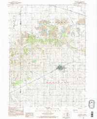
1994 Map of Neponset
USGS Topo · Published 1998About this map
Neponset serves as the primary hub in this corner of the Illinois prairie, situated along the Burlington Northern railroad corridor. The landscape is defined by the headwaters of the East Fork Spoon River and several drainage systems like Coal Creek and Lawson Creek that carve through the agricultural tableland. Local history is anchored by sites like Francis Park and the village streets of Main St and Chestnut St, while the northern portion of the quadrangle shows significant topographical variation from mining or quarrying activity in the Mineral township area. Genealogists will find several burial grounds documented, including Mineral Cem and the Floral Hill Cem located south of the village. The map also records specialized transit markers like the Bennett Landing Strip, reflecting the rural transportation network of the late 20th century.
Find a feature on this map
22 named features on this map. Tap any name to fly to it.
Don’t see what you’re looking for? This feature index may not catch every label — zoom into the map to look around manually.
Map Details
Editions of this 1994 Neponset Map
This is the sole edition of this map. No revisions or reprints were ever made.
Other maps of this area

1921 · Buda
USGS Topo · 1:62,500

1923 · Buda
USGS Topo · 1:62,500

1929 · Annawan
USGS Topo · 1:62,500

1932 · Annawan
USGS Topo · 1:62,500

1933 · Camp Grove
USGS Topo · 1:48,000

1944 · Kewanee
USGS Topo · 1:62,500

1945 · Bradford
USGS Topo · 1:62,500

1958 · Aurora
USGS Topo · 1:250,000

1961 · Aurora
USGS Topo · 1:250,000
1983 · Annawan
USGS Topo · 1:24,000