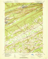
1950 Map of Nesquehoning
USGS Topo · Published 1950About this map
The steep ridges of the Coal Region define the landscape around Nesquehoning and Lansford at the turn of the 1950s. The town of Summit Hill sits high on the plateau between Nesquehoning Mountain and Mauch Chunk Mountain, while the Central Railroad of Pennsylvania follows the deep valley of Nesquehoning Creek. In contrast to the industrial character of the northern peaks, the southern portion of the map descends into the agricultural basins of Strauss Valley and Mahoning Creek.
Find a feature on this map
59 named features on this map. Tap any name to fly to it.
Don’t see what you’re looking for? This feature index may not catch every label — zoom into the map to look around manually.
Map Details
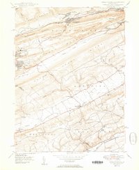
Editions of this 1950 Nesquehoning Map
2 editions found
Other maps of this area

1889 · Hazleton
USGS Topo · 1:62,500

1891 · Hazleton
USGS Topo · 1:62,500

1893 · Hazleton
USGS Topo · 1:62,500

1902 · Slatington
USGS Topo · 1:62,500

1909 · Hamburg
USGS Topo · 1:62,500

1911 · Hamburg
USGS Topo · 1:62,500

1922 · Mauch Chunk
USGS Topo · 1:62,500

1924 · Mauch Chunk
USGS Topo · 1:62,500

1937 · Allentown West
USGS Topo · 1:48,000

1942 · Allentown West
USGS Topo · 1:62,500