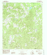
1984 Map of Neuville
USGS Topo · Published 1985About this map
Neuville stands as a focal point in this portion of Shelby County, situated within a landscape defined by an intricate network of timbered drainages and small settlements. The mid-1980s landscape shows a transition from traditional rural activities toward a geography of managed water, evidenced by Lake Center, New City Lake, and Bailey Lakes. Smaller hamlets like Choice, Short, and Jericho are scattered across the quadrangle, connected by a web of local roads and unimproved trails.
Find a feature on this map
29 named features on this map. Tap any name to fly to it.
Don’t see what you’re looking for? This feature index may not catch every label — zoom into the map to look around manually.
Map Details
Editions of this 1984 Neuville Map
This is the sole edition of this map. No revisions or reprints were ever made.
Other maps of this area

1953 · Palestine
USGS Topo · 1:250,000

1957 · Palestine
USGS Topo · 1:250,000

1958 · Center
USGS Topo · 1:62,500

1958 · San Augustine
USGS Topo · 1:62,500

1958 · Martinsville
USGS Topo · 1:62,500

1958 · Timpson
USGS Topo · 1:62,500

1984 · Palestine
USGS Topo · 1:250,000
1984 · Center
USGS Topo · 1:24,000
1984 · San Augustine East
USGS Topo · 1:24,000
1984 · Hurstown
USGS Topo · 1:24,000