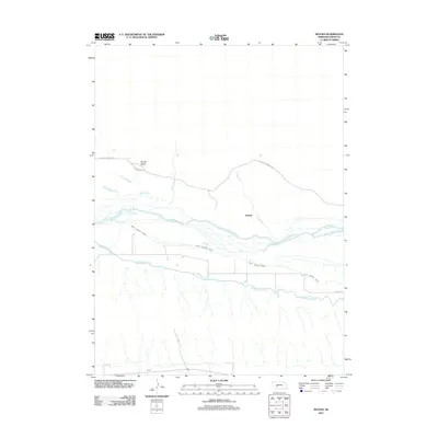
2011 Map of Nevens
USGS Topo · Published 2011About this map
The North Platte River creates a braided network of channels through this portion of Keith County, defining a landscape dominated by water management and ranching. The presence of the Keith Lincoln Canal and the Sutherland Canal running parallel to the river reflects the critical role of irrigation and hydropower infrastructure in this plains environment. To the north, the Buckhorn Springs Ranch sits near the headwaters of Skunk Creek and Duck Creek, while the settlement of Nevens is positioned where Lake Creek meets the river valley. In the southern portion of the sheet, the railroad and highway corridor near Korty follows the traditional path of transcontinental travel, bounded by the complex drainage patterns that feed into the Platte.
Find a feature on this map
13 named features on this map. Tap any name to fly to it.
Don’t see what you’re looking for? This feature index may not catch every label — zoom into the map to look around manually.
Map Details
Editions of this 2011 Nevens Map
This is the sole edition of this map. No revisions or reprints were ever made.
Other maps of this area

1897 · Ogallala
USGS Topo · 1:125,000

1898 · Paxton
USGS Topo · 1:125,000

1900 · Ogallala
USGS Topo · 1:125,000

1901 · Paxton
USGS Topo · 1:125,000

1954 · North Platte
USGS Topo · 1:250,000

1956 · North Platte
USGS Topo · 1:250,000

1957 · North Platte
USGS Topo · 1:250,000

1967 · North Platte
USGS Topo · 1:250,000
1971 · Ogallala SE
USGS Topo · 1:24,000
1971 · Paxton South
USGS Topo · 1:24,000