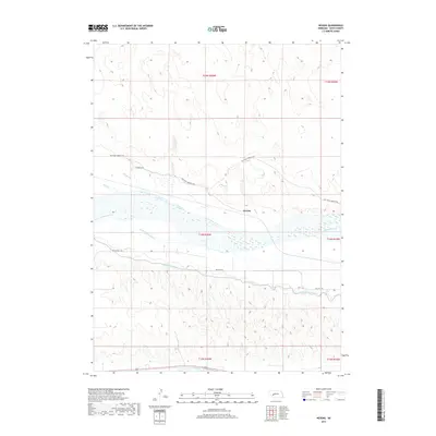
2017 Map of Nevens
USGS Topo · Published 2017About this map
North Platte River defines the central corridor of this Keith County landscape, flanked by an intricate network of irrigation and water management infrastructure. The settlement of Nevens sits just north of the river, positioned between the natural waterway and the engineered Keith Lincoln Canal and Sutherland Canal. These parallel channels reflect the region's historical reliance on intensive water diversion to support agriculture in the Nebraska panhandle. The terrain transition is marked by the braided appearance of the riverbed and numerous drainages like Duck Creek, Sand Creek, and Skunk Cr that feed into the valley from the north. The presence of Keystone Sarben N Rd highlights the rural connectivity of the area, linking the local ranching and farming operations that define the community's footprint near the river.
Find a feature on this map
19 named features on this map. Tap any name to fly to it.
Don’t see what you’re looking for? This feature index may not catch every label — zoom into the map to look around manually.
Map Details
Editions of this 2017 Nevens Map
This is the sole edition of this map. No revisions or reprints were ever made.
Other maps of this area

1897 · Ogallala
USGS Topo · 1:125,000

1898 · Paxton
USGS Topo · 1:125,000

1900 · Ogallala
USGS Topo · 1:125,000

1901 · Paxton
USGS Topo · 1:125,000

1954 · North Platte
USGS Topo · 1:250,000

1956 · North Platte
USGS Topo · 1:250,000

1957 · North Platte
USGS Topo · 1:250,000

1967 · North Platte
USGS Topo · 1:250,000
1971 · Ogallala SE
USGS Topo · 1:24,000
1971 · Paxton South
USGS Topo · 1:24,000