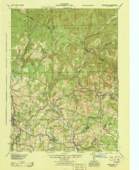
1944 Map of Neversink
USGS Topo · Published 1944About this map
Neversink and the surrounding Catskill highlands appear here in a 1944 survey that captures the region's transition from a quiet river-valley economy to a more established residential and seasonal landscape. The map centers on the Neversink River and its branches, including the West Branch and East Branch, before many of these valleys were significantly altered by mid-century reservoir construction. Prominent mountain peaks such as Denman Mt and Blue Hill overlook a network of small hamlets like Grahamsville, Claryville, and Curry. To the southwest, the Nyo And W Rr serves the growing community of Liberty, a vital link for the local economy. The landscape is dotted with numerous bodies of water, from the resort-adjacent Loch Sheldrake to smaller mountain pools like Hodge Pond and Mongaup Pond, illustrating the area's enduring character as a destination for outdoor recreation and summer retreats.
Find a feature on this map
75 named features on this map. Tap any name to fly to it.
Don’t see what you’re looking for? This feature index may not catch every label — zoom into the map to look around manually.
Map Details
Editions of this 1944 Neversink Map
This is the sole edition of this map. No revisions or reprints were ever made.
Other maps of this area

1900 · Phoenicia
USGS Topo · 1:62,500

1901 · Margaretville
USGS Topo · 1:62,500

1903 · Phoenicia
USGS Topo · 1:62,500

1903 · Slide Mountain
USGS Topo · 1:62,500

1904 · Margaretville
USGS Topo · 1:62,500

1904 · Ellenville
USGS Topo · 1:62,500

1905 · Slide Mountain
USGS Topo · 1:62,500

1906 · Ellenville
USGS Topo · 1:62,500

1909 · Monticello
USGS Topo · 1:62,500

1910 · Neversink
USGS Topo · 1:62,500