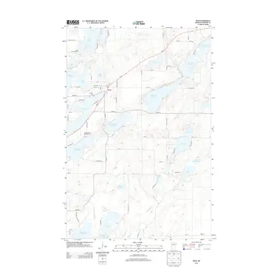
2013 Map of Nevis
USGS Topo · Published 2013About this map
The resort town of Nevis serves as a central hub for this lake-dotted portion of Hubbard County, situated along the northern shore of Lake Belle Taine. The landscape is dominated by the chain of the Crow Wing River, featuring a series of numbered water bodies from Third Crow Wing Lake in the south up to Tenth Crow Wing Lake in the northeast. This 2013 survey illustrates the dense concentration of recreational and residential development typical of Minnesota's lake country, with sites like the Wildridge Resort and Campground and Nature Land Campground bordering the water. Local history and genealogy interests are anchored by Lakeview Cem near the town center and Lemon Cem in the southeast. A complex network of local roads such as Co HWY-13 and MN-34 connects the many smaller lakes, including Island Lake, Ham Lake, and the uniquely named Holland-Lucy Lake.
Find a feature on this map
81 named features on this map. Tap any name to fly to it.
Don’t see what you’re looking for? This feature index may not catch every label — zoom into the map to look around manually.
Map Details
Editions of this 2013 Nevis Map
This is the sole edition of this map. No revisions or reprints were ever made.
Other maps of this area

1953 · Brainerd
USGS Topo · 1:250,000

1954 · Bemidji
USGS Topo · 1:250,000

1957 · Brainerd
USGS Topo · 1:250,000

1957 · Bemidji
USGS Topo · 1:250,000

1958 · Bemidji
USGS Topo · 1:250,000

1958 · Brainerd
USGS Topo · 1:250,000

1965 · Brainerd
USGS Topo · 1:250,000

1970 · Nevis
USGS Topo · 1:24,000

1970 · Dorset
USGS Topo · 1:24,000
1970 · Huntersville
USGS Topo · 1:24,000