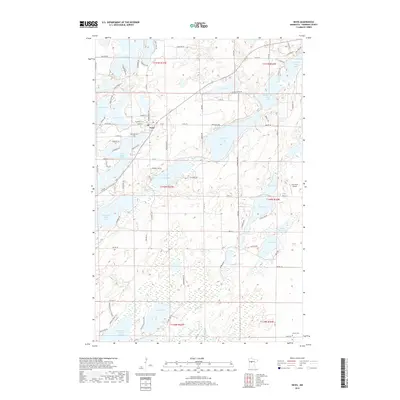
2019 Map of Nevis
USGS Topo · Published 2019About this map
Nevis serves as the central hub of this lake-strewn landscape in Hubbard County, where the Crow Wing River system creates a distinctive chain of water bodies. The geography is defined by a series of numbered lakes, including Tenth Crow Wing Lake, Ninth Crow Wing Lake, Eighth Crow Wing Lake, Seventh Crow Wing Lake, and Sixth Crow Wing Lake, which form a navigational corridor through the glacial terrain. North of the town center, Deer Lake and Spider Lake dominate the northern quadrants, while Lake Belle Taine sits immediately to the south. Local history and genealogy are represented by the Lakeview Cem near the town site and the more remote Lemon Cem in the southeastern corner. The inclusion of Bunyan Trails Rd alludes to the region's cultural connection to timber heritage and recreation.
Find a feature on this map
89 named features on this map. Tap any name to fly to it.
Don’t see what you’re looking for? This feature index may not catch every label — zoom into the map to look around manually.
Map Details
Editions of this 2019 Nevis Map
This is the sole edition of this map. No revisions or reprints were ever made.
Other maps of this area

1953 · Brainerd
USGS Topo · 1:250,000

1954 · Bemidji
USGS Topo · 1:250,000

1957 · Brainerd
USGS Topo · 1:250,000

1957 · Bemidji
USGS Topo · 1:250,000

1958 · Bemidji
USGS Topo · 1:250,000

1958 · Brainerd
USGS Topo · 1:250,000

1965 · Brainerd
USGS Topo · 1:250,000

1970 · Nevis
USGS Topo · 1:24,000

1970 · Dorset
USGS Topo · 1:24,000
1970 · Huntersville
USGS Topo · 1:24,000