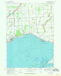
1968 Map of New Baltimore
USGS Topo · Published 1971About this map
Anchor Bay dominates the coastline of this survey, where the border of Macomb and St. Clair counties meets the northern reaches of Lake St Clair. The settlement of New Baltimore marks the western edge, featuring a Sewage Disposal plant and a developed park system near Crapaud Creek. Moving east along the shoreline, the communities of Anchorville and Fair Haven are linked by a network of drainage systems like Meldrum Creek and Swan Creek. The map documents a blend of recreation and utility, capturing the Motor City Drag Strip situated near the Ira Gas Storage Field and a Gas Processing Plant. To the south, the intricate marshlands of the St Clair Flats State Wildlife Area emerge, defined by the North Channel and the Dickinson Island Flats, illustrating the unique transitional landscape where the river system opens into the bay.
Find a feature on this map
59 named features on this map. Tap any name to fly to it.
Don’t see what you’re looking for? This feature index may not catch every label — zoom into the map to look around manually.
Map Details
Editions of this 1968 New Baltimore Map
2 editions found
Other maps of this area

1912 · Mt Clemens
USGS Topo · 1:62,500

1914 · Armada
USGS Topo · 1:62,500

1914 · Algonac
USGS Topo · 1:62,500

1928 · Armada
USGS Topo · 1:62,500

1928 · Hicky
USGS Topo · 1:62,500

1929 · Mt Clemens
USGS Topo · 1:62,500

1936 · New Haven
USGS Topo · 1:31,680

1936 · Rattle Run
USGS Topo · 1:31,680

1936 · Selfridge Field
USGS Topo · 1:31,680

1936 · New Baltimore
USGS Topo · 1:31,680