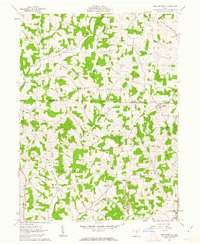
1961 Map of New Bedford
USGS Topo · Published 1963About this map
New Bedford sits at the high-point divide of the eastern edge of this 1961 survey, where rural life in Holmes and Coshocton counties revolves around a dense network of country schools and churches. The landscape is deeply carved by drainage systems like Doughty Creek and Mill Creek, supporting small agricultural hamlets such as Becks Mills and Chili. The presence of a localized Townhall and several named schools, including Flat Ridge Sch and Green Ridge Sch, indicates a well-established township structure in Mechanic and Crawford.
Find a feature on this map
36 named features on this map. Tap any name to fly to it.
Don’t see what you’re looking for? This feature index may not catch every label — zoom into the map to look around manually.
Map Details
Editions of this 1961 New Bedford Map
2 editions found
Other maps of this area

1911 · Newcomerstown
USGS Topo · 1:62,500

1913 · Newcomerstown
USGS Topo · 1:62,500

1913 · Coshocton
USGS Topo · 1:62,500

1914 · Navarre
USGS Topo · 1:62,500

1915 · Millersburg
USGS Topo · 1:62,500

1915 · Coshocton
USGS Topo · 1:62,500

1943 · Millersburg
USGS Topo · 1:62,500

1943 · Coshocton
USGS Topo · 1:62,500

1943 · Newcomerstown
USGS Topo · 1:62,500

1944 · Navarre
USGS Topo · 1:62,500