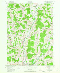
1943 Map of New Berlin North
USGS Topo · Published 1972About this map
The Unadilla River and the parallel Unadilla Valley River rail line define the central corridor of this 1940s landscape, marking the border between Chenango and Otsego counties. This rural landscape is characterized by a series of small, crossroad hamlets and family-named corners such as Millers Corners, Lambs Corners, and Briggs Corners. The importance of local education and community is evident through the presence of numbered rural schools like Town Sch No 3 and Town Sch No 9, alongside the Columbus Church. At the southern end of the sheet, the village of New Berlin sits near the Hoboken dam, serving as a primary settlement node. The map's detailed topography reveals the complex drainage patterns of the Sherburne Valley and the Unadilla Valley, where numerous brooks and creeks, including Tallette Brook and Wharton Creek, carve through the surrounding hills.
Find a feature on this map
45 named features on this map. Tap any name to fly to it.
Don’t see what you’re looking for? This feature index may not catch every label — zoom into the map to look around manually.
Map Details
Editions of this 1943 New Berlin North Map
4 editions found
Other maps of this area

1907 · Winfield
USGS Topo · 1:62,500

1907 · Sangerfield
USGS Topo · 1:62,500

1910 · Hartwick
USGS Topo · 1:62,500

1910 · New Berlin
USGS Topo · 1:62,500

1912 · New Berlin
USGS Topo · 1:62,500

1912 · Hartwick
USGS Topo · 1:62,500

1943 · New Berlin North
USGS Topo · 1:24,000

1943 · New Berlin South
USGS Topo · 1:24,000

1943 · Hubbardsville
USGS Topo · 1:24,000

1943 · Unadilla Forks
USGS Topo · 1:24,000