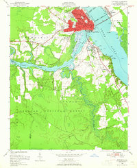
1950 Map of New Bern
USGS Topo · Published 1965About this map
The confluence of the Neuse River and Trent River anchors this mid-century view of New Bern, North Carolina. The city's historic layout is visible through a cluster of civic and spiritual landmarks, including the Courthouse, Post Office, and a dense concentration of burial grounds such as the National Cem and Cedar Grove Cem. Beyond the developed core, the landscape transitions from the suburban neighborhoods of De Graffenried Park and James City into the dense timber and swampland of the Croatan National Forest to the south.
Find a feature on this map
49 named features on this map. Tap any name to fly to it.
Don’t see what you’re looking for? This feature index may not catch every label — zoom into the map to look around manually.
Map Details
Editions of this 1950 New Bern Map
5 editions found
Other maps of this area

1901 · New Bern
USGS Topo · 1:62,500

1903 · New Bern
USGS Topo · 1:62,500

1942 · Maysville
USGS Topo · 1:62,500

1948 · Maysville
USGS Topo · 1:62,500

1949 · Havelock
USGS Topo · 1:24,000

1950 · Pollocksville
USGS Topo · 1:24,000

1950 · New Bern
USGS Topo · 1:24,000

1950 · Upper Broad Creek
USGS Topo · 1:24,000

1951 · Upper Broad Creek
USGS Topo · 1:24,000

1953 · Rocky Mount
USGS Topo · 1:250,000