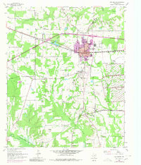
1954 Map of New Boston
USGS Topo · Published 1980About this map
The Bowie County Courthouse stands as a focal point south of New Boston, marking the geographic transition from the busy Texas and Pacific rail line to the rural settlements of Old Boston and Boston. This mid-century landscape is defined by its social infrastructure, featuring numerous country churches and cemeteries like Godley Prairie Ch and McWright Cem that reflect deep-rooted family ties in Bowie County. The eastern portion of the map is dominated by the sprawling Red River Arsenal, while the southern reaches are shaped by the waters of Wright Patman Lake. Traces of earlier life appear in the placement of the Highway Sch and the Magnetic High Sch, highlighting the importance of local education during this era of post-war development in Northeast Texas.
Find a feature on this map
51 named features on this map. Tap any name to fly to it.
Don’t see what you’re looking for? This feature index may not catch every label — zoom into the map to look around manually.
Map Details
Editions of this 1954 New Boston Map
4 editions found
Other maps of this area

1909 · New Boston
USGS Topo · 1:62,500

1930 · Bassett
USGS Topo · 1:62,500

1950 · Redbank
USGS Topo · 1:24,000

1950 · De Kalb
USGS Topo · 1:24,000

1951 · De Kalb
USGS Topo · 1:24,000

1951 · Redbank
USGS Topo · 1:24,000

1951 · Daniels Chapel
USGS Topo · 1:24,000

1953 · Texarkana
USGS Topo · 1:250,000

1954 · New Boston
USGS Topo · 1:24,000

1954 · Hooks
USGS Topo · 1:24,000