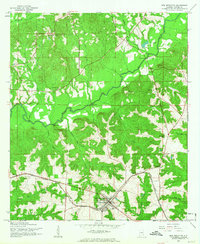
1960 Map of New Brockton
USGS Topo · Published 1963About this map
New Brockton serves as the focal point of this 1960 survey, situated along the Atlantic Coast Line railroad in rural Coffee County. The landscape is defined by the winding course of the Pea River, which is traversed by several significant crossings such as Weeks Bridge, Roe Bridge, and Folsom Bridge. This era shows a community structured around small settlements and agrarian centers, evidenced by the cluster of local landmarks like New Brockton High Sch and the many country churches including Shiloh Ch and Collins Chapel Ch.
Find a feature on this map
33 named features on this map. Tap any name to fly to it.
Don’t see what you’re looking for? This feature index may not catch every label — zoom into the map to look around manually.
Map Details
Editions of this 1960 New Brockton Map
2 editions found
Other maps of this area

1942 · Enterprise
USGS Topo · 1:125,000

1948 · Brundidge
USGS Topo · 1:62,500

1950 · Enterprise
USGS Topo · 1:62,500

1950 · Brundidge
USGS Topo · 1:62,500

1953 · Andalusia
USGS Topo · 1:250,000

1953 · Dothan
USGS Topo · 1:250,000

1954 · Dothan
USGS Topo · 1:250,000

1955 · Dothan
USGS Topo · 1:250,000

1957 · Andalusia
USGS Topo · 1:250,000

1960 · Brundidge SE
USGS Topo · 1:24,000