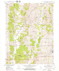
1950 Map of New Cambria West
USGS Topo · Published 1979About this map
Mussel Fork and its numerous tributaries, including Dutch Creek and Hickory Branch, dominate this rural landscape on the border of Linn and Macon Counties. The map captures a mid-century agricultural region structured around two primary rail corridors. To the north, the Atchison Topeka and Santa Fe railroad winds through the hills past the small settlement of Hart, while the Chicago Burlington and Quincy line serves the southern portion near Lingo. Local community life is evidenced by a dense network of country schools and churches, such as Lundy School and the Mt Zion Church. The eastern edge is anchored by New Cambria, showing the town’s residential layout and proximity to St. Mary Cemetery. This topographic record provides exceptional detail for genealogists, preserving the locations of family burial grounds like Tuttle Cemetery and Dowell Cemetery that serve as vital links to the area's early residents.
Find a feature on this map
29 named features on this map. Tap any name to fly to it.
Don’t see what you’re looking for? This feature index may not catch every label — zoom into the map to look around manually.
Map Details
Editions of this 1950 New Cambria West Map
2 editions found
Other maps of this area

1937 · Elmer
USGS Topo · 1:48,000

1942 · Elmer
USGS Topo · 1:62,500

1949 · Bucklin
USGS Topo · 1:24,000

1949 · Bucklin NW
USGS Topo · 1:24,000

1950 · Bucklin
USGS Topo · 1:24,000

1950 · New Cambria West
USGS Topo · 1:24,000

1950 · Bucklin NW
USGS Topo · 1:24,000

1951 · New Boston
USGS Topo · 1:24,000

1953 · Moberly
USGS Topo · 1:250,000

1953 · Marceline
USGS Topo · 1:24,000