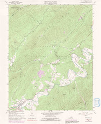
1966 Map of New Castle
USGS Topo · Published 1991About this map
Craig Creek meanders through this valley in the Jefferson National Forest, anchoring a landscape defined by small mountain settlements and industrial remnants. In the southwestern corner, New Castle serves as a hub of activity, featuring a Drive-in Theater and Sewage Disposal facilities alongside the riverbanks. The influence of local mineral resources is evident at Virginia Mineral Springs and the Fenwick Mines Campground, reflecting the region's intersection of 1960s outdoor recreation and older extractive history.
Find a feature on this map
55 named features on this map. Tap any name to fly to it.
Don’t see what you’re looking for? This feature index may not catch every label — zoom into the map to look around manually.
Map Details
Editions of this 1966 New Castle Map
3 editions found
Other maps of this area

1887 · Lewisburg
USGS Topo · 1:125,000

1890 · Roanoke
USGS Topo · 1:125,000

1890 · Christiansburg
USGS Topo · 1:125,000

1891 · Roanoke
USGS Topo · 1:125,000

1891 · Lewisburg
USGS Topo · 1:125,000

1894 · Natural Bridge
USGS Topo · 1:125,000

1913 · Eagle Rock
USGS Topo · 1:48,000

1915 · Eagle Rock
USGS Topo · 1:62,500

1929 · Roanoke
USGS Topo · 1:48,000

1929 · Salem
USGS Topo · 1:48,000