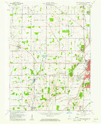
1960 Map of New Castle West
USGS Topo · Published 1979About this map
The agricultural heart of Henry County unfolds across this 1960 landscape, centered on the western expansion of New Castle and the rural hamlets of Cadiz and Mt Lawn. The western edge of the county seat is characterized by public institutions and recreation, including the County Home, Memorial Park, and the sprawling South Mound Cemetery. Small rural hubs like Westwood and the village of Foley anchor the surrounding townships, while the Western Airfield and a Drive-In Theater reflect the mid-century suburbanization of the Indiana countryside.
Find a feature on this map
66 named features on this map. Tap any name to fly to it.
Don’t see what you’re looking for? This feature index may not catch every label — zoom into the map to look around manually.
Map Details
Editions of this 1960 New Castle West Map
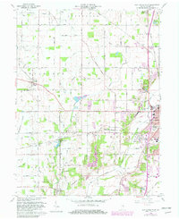
Other maps of this area

1948 · Lewisville
USGS Topo · 1:24,000

1949 · New Castle West
USGS Topo · 1:24,000

1950 · New Castle East
USGS Topo · 1:24,000

1950 · Dunreith
USGS Topo · 1:24,000

1950 · Lewisville
USGS Topo · 1:24,000

1953 · Cincinnati
USGS Topo · 1:250,000

1953 · Muncie
USGS Topo · 1:250,000

1956 · Muncie
USGS Topo · 1:250,000

1957 · Cincinnati
USGS Topo · 1:250,000

1960 · New Castle West
USGS Topo · 1:24,000