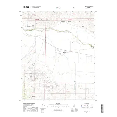
2018 Map of New Cuyama
USGS Topo · Published 2018About this map
New Cuyama and its surrounding desert landscape are defined by the convergence of steep canyons and seasonal watercourses. This late 2010s survey captures the community and the New Cuyama Airport at the intersection of Perkins Rd and Morales St. The terrain transitions from the dry bed of the Cuyama River in the north to the rising elevations of the Los Padres National Forest and the Sierra Madre Mountains in the south. Named drainages such as Br Canyon Wash and Salisbury Canyon Wash illustrate the complex hydrological network of the valley floor. To the north, the boundary between Santa Barbara and San Luis Obispo counties follows the river, while prominent landmarks like Turkey Trap Ridge and numerous named canyons, including Bee Rock Canyon and Windmill Canyon, mark the rugged topography of the foothills.
Find a feature on this map
42 named features on this map. Tap any name to fly to it.
Don’t see what you’re looking for? This feature index may not catch every label — zoom into the map to look around manually.
Map Details
Editions of this 2018 New Cuyama Map
This is the sole edition of this map. No revisions or reprints were ever made.
Other maps of this area

1902 · Santa Ynez
USGS Topo · 1:125,000

1905 · Santa Ynez
USGS Topo · 1:125,000

1912 · McKittrick
USGS Topo · 1:125,000

1941 · Caliente Mountain
USGS Topo · 1:62,500

1941 · McPherson Peak
USGS Topo · 1:62,500

1942 · Caliente Mtn
USGS Topo · 1:62,500

1942 · East of Cuyama Ranch
USGS Topo · 1:24,000

1943 · McPherson Peak
USGS Topo · 1:62,500

1943 · Caliente Mtn.
USGS Topo · 1:62,500

1943 · Cuyama Ranch
USGS Topo · 1:31,680