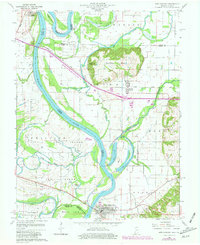
1959 Map of New Harmony
USGS Topo · Published 1981About this map
The Wabash River meanders across this landscape at the intersection of Indiana and Illinois, defining the shifting boundaries of White, Gibson, and Posey counties. This survey shows the area during a period of transition, where the natural hydrology of Big Bayou, Goose Pond, and Rattling Slough contrasts with the industrial footprint of the Illinois Central Gulf railroad and several pipelines. The town of New Harmony sits at the southern edge, its street grid established near the riverbanks, while the smaller settlement of Griffin is positioned further north near the base of the Mumford Hills. Genealogists will find several rural burial sites, including Mt Pleasant Cem and Stillwell Cem, which serve as anchors for the local family history of the area's agricultural and river-fronting townships.
Find a feature on this map
43 named features on this map. Tap any name to fly to it.
Don’t see what you’re looking for? This feature index may not catch every label — zoom into the map to look around manually.
Map Details
Editions of this 1959 New Harmony Map
4 editions found
Other maps of this area

1903 · New Harmony
USGS Topo · 1:62,500

1903 · Patoka
USGS Topo · 1:125,000

1904 · Mount Carmel
USGS Topo · 1:62,500

1938 · New Harmony
USGS Topo · 1:62,500

1940 · Carmi
USGS Topo · 1:62,500

1943 · Carmi
USGS Topo · 1:62,500

1943 · Albion
USGS Topo · 1:62,500

1946 · Albion
USGS Topo · 1:62,500

1956 · Vincennes
USGS Topo · 1:250,000

1957 · Vincennes
USGS Topo · 1:250,000