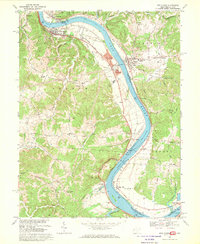
1968 Map of New Haven
USGS Topo · Published 1969About this map
The Ohio River carves a sharp serpentine path through this 1960s riverfront landscape, dividing the communities of New Haven and Hartford, West Virginia, from their neighbors in Syracuse and Racine, Ohio. This corridor is defined by the heavy infrastructure of the era, including the Baltimore and Ohio railroad line tracing the riverbank and the industrial presence of a powerplant and Graham Station. While the river serves as a modern industrial artery, ancient history remains visible at the Indian Mound near Dorcas, and the river’s natural hazards are marked by Letart Falls.
Find a feature on this map
91 named features on this map. Tap any name to fly to it.
Don’t see what you’re looking for? This feature index may not catch every label — zoom into the map to look around manually.
Map Details
Editions of this 1968 New Haven Map
3 editions found
Other maps of this area

1907 · Pomeroy
USGS Topo · 1:62,500

1907 · Keno
USGS Topo · 1:62,500

1908 · Ravenswood
USGS Topo · 1:62,500

1908 · Point Pleasant
USGS Topo · 1:62,500

1926 · Ravenswood
USGS Topo · 1:62,500

1926 · Point Pleasant
USGS Topo · 1:62,500

1928 · Ravenswood
USGS Topo · 1:62,500

1929 · Point Pleasant
USGS Topo · 1:62,500

1947 · Columbus
USGS Topo · 1:250,000

1949 · Clarksburg
USGS Topo · 1:250,000