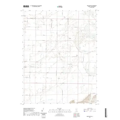
2021 Map of New Haven SW
USGS Topo · Published 2021About this map
Ridgway and the nearby community of Inman anchor this agricultural landscape in southern Illinois, where the terrain transitions from the low-lying drainage of the Wabash River floodplain to the rising elevations of the Shawneetown Hills. The area is defined by an intricate network of waterways and drainage features, including the Pond Settlement Ditch, Crackle Ditch, and Cattail Slough, reflecting the ongoing effort to manage the local hydrology for cultivation.
Find a feature on this map
68 named features on this map. Tap any name to fly to it.
Don’t see what you’re looking for? This feature index may not catch every label — zoom into the map to look around manually.
Map Details
Editions of this 2021 New Haven SW Map
This is the sole edition of this map. No revisions or reprints were ever made.
Other maps of this area

1905 · Eldorado
USGS Topo · 1:62,500

1905 · New Haven
USGS Topo · 1:62,500

1906 · New Haven
USGS Topo · 1:62,500

1906 · Eldorado
USGS Topo · 1:62,500

1916 · Shawneetown
USGS Topo · 1:62,500

1916 · Equality
USGS Topo · 1:62,500

1949 · Paducah
USGS Topo · 1:250,000

1949 · New Haven
USGS Topo · 1:62,500

1950 · Paducah
USGS Topo · 1:250,000
1953 · Wabash Island
USGS Topo · 1:24,000