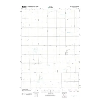
2012 Map of New Holland
USGS Topo · Published 2012About this map
New Holland Lake sits at the heart of this agricultural landscape in Douglas County, surrounded by a precise grid of sectional roads and drainage works. The map documents a rural community centered around several established burial grounds, including the New Holland Cem and Harrison Cem. The influence of water management on the Great Plains is evident through the presence of the Garden Valley Ditch and the winding Meadow Drain, which cut across the organized road network. A small cluster of residential streets such as Lecoco St and Vanden Bos Ave indicates a concentrated settlement pattern amidst the expansive farmsteads of Holland Township. This survey provides a clear look at the spatial arrangement of cemeteries and rural infrastructure in South Dakota at the beginning of the second decade of the 21st century.
Find a feature on this map
29 named features on this map. Tap any name to fly to it.
Don’t see what you’re looking for? This feature index may not catch every label — zoom into the map to look around manually.
Map Details
Editions of this 2012 New Holland Map
This is the sole edition of this map. No revisions or reprints were ever made.
Other maps of this area

1899 · Mitchell
USGS Topo · 1:125,000

1955 · Mitchell
USGS Topo · 1:250,000

1959 · Mitchell
USGS Topo · 1:250,000

1979 · Geddes SE
USGS Topo · 1:24,000
1979 · Geddes
USGS Topo · 1:24,000

1979 · New Holland
USGS Topo · 1:24,000

1979 · Laffey Lake
USGS Topo · 1:24,000

1979 · Aurora Center
USGS Topo · 1:24,000

1979 · Joubert
USGS Topo · 1:24,000
1979 · Armour SW
USGS Topo · 1:24,000