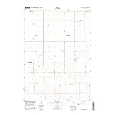
2015 Map of New Holland
USGS Topo · Published 2015About this map
New Holland and Harrison anchor this rural landscape in Douglas County, reflecting the deep-rooted agricultural settlement of the South Dakota prairie. The map illustrates a strictly organized section-line road grid, including 273rd St and 379th Ave, which connect isolated farmsteads and local landmarks. Genealogists will find significant value in the documentation of three distinct burial sites: New Holland Cem, Harrison Cem, and Ebenezer Cem, each serving the surrounding rural community. Water management is a defining characteristic of the terrain, visible through the systematic engineering of Meadow Drain and the Garden Valley Ditch, while New Holland Lake provides a natural break in the rolling topography. The presence of these drainage features alongside the township boundaries of t100n r66w and t99n r65w highlights the intersection of natural hydrology and formal land division in the early 21st century.
Find a feature on this map
32 named features on this map. Tap any name to fly to it.
Don’t see what you’re looking for? This feature index may not catch every label — zoom into the map to look around manually.
Map Details
Editions of this 2015 New Holland Map
This is the sole edition of this map. No revisions or reprints were ever made.
Other maps of this area

1899 · Mitchell
USGS Topo · 1:125,000

1955 · Mitchell
USGS Topo · 1:250,000

1959 · Mitchell
USGS Topo · 1:250,000

1979 · Geddes SE
USGS Topo · 1:24,000
1979 · Geddes
USGS Topo · 1:24,000

1979 · New Holland
USGS Topo · 1:24,000

1979 · Laffey Lake
USGS Topo · 1:24,000

1979 · Aurora Center
USGS Topo · 1:24,000

1979 · Joubert
USGS Topo · 1:24,000
1979 · Armour SW
USGS Topo · 1:24,000