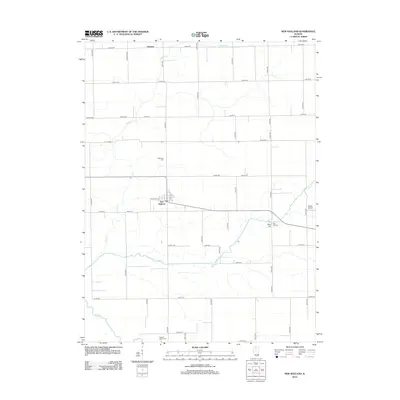
2012 Map of New Holland
USGS Topo · Published 2012About this map
New Holland stands as the primary hub of this Logan County landscape, situated at the junction of W Lincoln St and Page St. The surrounding countryside is defined by a rigid grid of agricultural roads, including Co Rd 3900 and 200th Ave, which carve through the fertile terrain between Prairie Cr and Sugar Cr. To the north lies the small settlement of Harness, while the southern reaches of the map are bounded by the winding course of Salt Cr. Local history is anchored by several rural burial sites, such as Stephen's Cem and Pleasant Valley Cem, providing key points of interest for genealogists tracking early families in the region. The map also records mid-century infrastructure like Martin Airport and the prominent rise of Pool Hill, which sits adjacent to Pool Hill Cem in the eastern section of the quadrangle.
Find a feature on this map
49 named features on this map. Tap any name to fly to it.
Don’t see what you’re looking for? This feature index may not catch every label — zoom into the map to look around manually.
Map Details
Editions of this 2012 New Holland Map
This is the sole edition of this map. No revisions or reprints were ever made.
Other maps of this area

1911 · Lincoln
USGS Topo · 1:62,500

1913 · Lincoln
USGS Topo · 1:62,500

1942 · Delavan
USGS Topo · 1:62,500

1948 · Mason City
USGS Topo · 1:62,500

1949 · Mason City
USGS Topo · 1:62,500

1951 · Minier
USGS Topo · 1:62,500

1958 · Peoria
USGS Topo · 1:250,000

1961 · Peoria
USGS Topo · 1:250,000

1963 · Peoria
USGS Topo · 1:250,000
1980 · Lincoln West
USGS Topo · 1:24,000